The Washington Post
Inside U.S. blockade, laden tankers depart Iranian ports and empty ones arrive
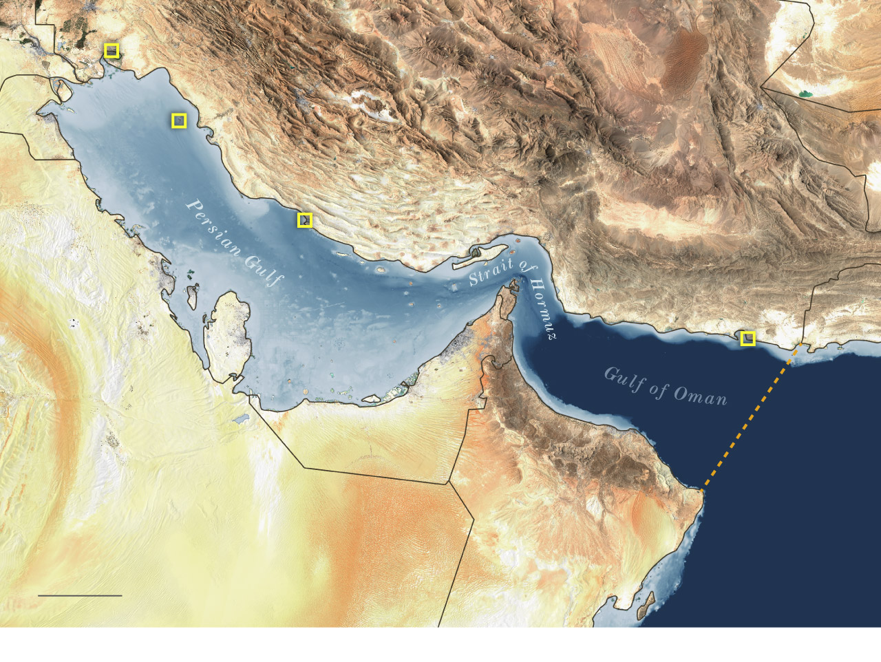
A Post analysis of satellite imagery and ship-tracking data provides a view of maritime activity inside the U.S. naval blockade.

The Post’s analysis of satellite imagery and ship-tracking data, along with interviews, provides a partial view of maritime activity inside the U.S. blockade. It identified the 10 ships engaged in activity that appears to make them subject to the blockade, and it shows that oil continues to flow from Iranian facilities — even if the ships carrying it remain inside the blockade’s perimeter.
On Friday, Iran announced that it is reopening the Strait of Hormuz, a passage it had throttled after U.S. and Israeli attacks began on Feb. 28. President Donald Trump posted to Truth Social moments later that the strait is open but that the blockade will remain in effect “UNTIL SUCH TIME AS OUR TRANSACTION WITH IRAN IS 100% COMPLETE.” Trump has suggested the United States and Iran are close to a peace deal.
The blockade involves 10,000 American troops, more than a dozen Navy ships and an array of fighter jets and drones, U.S. Central Command has said. When it was announced, officials said the blockade would be enforced against vessels of all nations entering or departing Iranian ports and coastlines; ships traveling to and from non-Iranian ports are not subject to the blockade.
The blockade put pressure on Tehran to stop restricting ship traffic through the strategic Strait of Hormuz. In a news briefing Thursday, Gen. Dan Caine, chairman of the Joint Chiefs of Staff, presented a map showing a “blockade line” spanning the Gulf of Oman, from the Iran-Pakistan border in the north to the Ras al Hadd peninsula in Oman in the south.
IRAQ
Bandar Mahshahr
IRAN
KWT.
Kharg
Assaluyeh
PAK.
Chabahar
QAT.
U.S. BLOCKADE LINE
UNITED ARAB EMIRATES
SAUDI ARABIA
OMAN
100 MILES
THE WASHINGTON POST
A U.S. official familiar with the blockade operation acknowledged that tankers remain active around Iranian ports. The official, who spoke on the condition of anonymity to discuss the sensitive military operation, said U.S. forces are tracking “double digits” numbers of vessels of interest within the blockade boundary. A fleet of U.S. destroyers are parked in the Gulf and prepared to intercept vessels as needed, the official said.
“We’re using geography to our advantage,” the official said.
By enforcing the blockade in the Gulf of Oman, U.S. forces can avoid the shallower, more constricted waters of the Persian Gulf and take advantage of the speed of destroyers, which can travel 30 to 35 mph. The typical oil tanker travels at about 15 mph, with the potential to go slightly faster, according to listed ship specifications.
Caine said Thursday that the U.S. mission “is a blockade of Iran’s ports and coastline, not a blockade of the Strait of Hormuz.” Enforcement, he said, will occur both in Iranian territorial waters and international waters, with U.S. forces “actively pursuing any Iranian-flagged vessel or any vessel attempting to provide material support to Iran” that leaves the Middle East and reaches the Indian Ocean and beyond.
Any vessel deemed to be violating the conditions of the blockade and attempting to leave the region will receive a warning from the lead U.S. ship at the time, normally a destroyer backed by airpower from the aircraft carrier USS Abraham Lincoln, Caine said.
As of Friday morning, 19 ships had turned back from the blockade rather than contend with it, U.S. military officials said.
The empty ships arriving
Satellite imagery captured Thursday showed three Iranian tankers, Hilda 1, Silvia I and Amber docked at Kharg Island, which processes 90 percent of Iran’s oil exports. All three ships loaded a combined total of 5 million barrels of crude oil, according to Tanker Trackers, an independent oil shipment tracker.
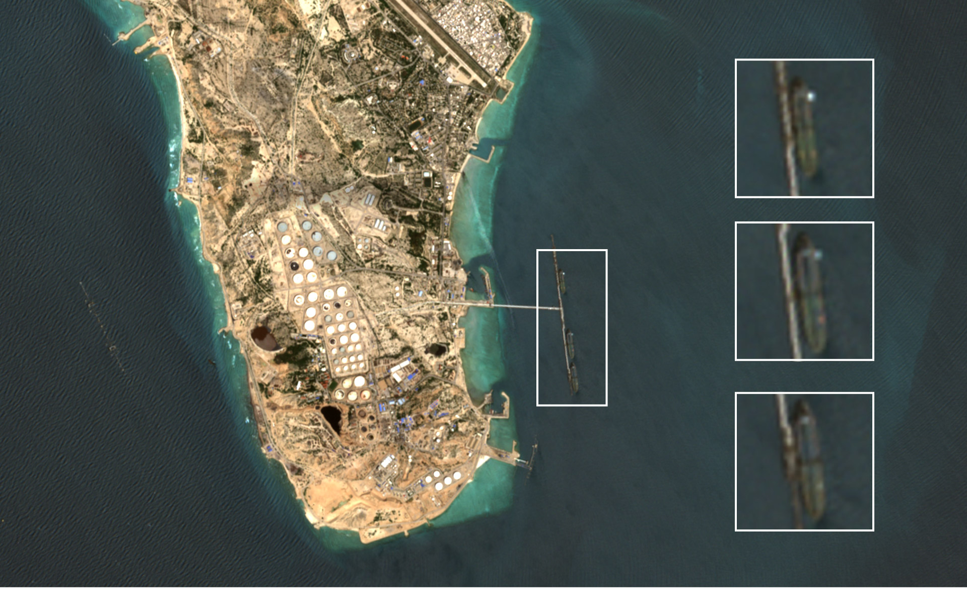
Silvia I
KHARG
Amber
Detail area
Hilda 1
Satellite image captured April 16 © Sentinel-2, European Space Agency 2026
Kharg is an integral part of Iran’s oil system. Crude flows from the mainland into the storage at the terminal. The storage system must be continually off-loaded to prevent potential damage and to avoid costly shutdowns, according to experts.
“The ships themselves act as floating storage,” said Petras Katinas, an energy researcher at the Royal United Services Institute, a defense and security think tank in London. “They allow Iran to keep oil moving out of the system and avoid a buildup that would force shut ins.”
Around 100 miles away, at Bandar Mahshahr, Iran’s northernmost port in the Persian Gulf, satellite imagery taken Thursday shows a fourth Iranian tanker, Arnica, loading fuel oil, according to Tanker Trackers. The data provider also identified the Panama-flagged, Chinese-owned ship Yong Tai in satellite imagery taken Wednesday of Iran’s Assaluyeh Port, southeast of Bandar Mahshahr. That ship was loading a product derived from crude oil, according to Tanker Trackers.


Other tankers that have historically transported Iranian oil have transited the Strait into the Persian Gulf in recent days, though ship-tracking data from the maritime intelligence firm Kpler indicates they have not yet docked. Experts note that such data can also be spoofed, allowing ships to transmit inaccurate coordinates and hide their locations.
Supertanker Alicia, flying under the flag of Curaçao, a Dutch-Caribbean island, sailed westward through the Strait of Hormuz on Wednesday into the Persian Gulf, according to ship-tracking data. The U.S.-sanctioned ship hugged Iranian territorial waters, sailing north of Larak Island, an area that has been described as Iran’s tollbooth since the country began restricting maritime access in the strategic corridor.
Around 12 hours later, a U.S.-sanctioned tanker called Rhn, flying under the same flag, appeared to take the same route, according to Kpler data. The vessel is reporting a nonspecific destination and is likely attempting a Kharg Island loading run, according to Kpler.
The laden ships departing
Iranian ships have been loitering in recent days near Iran’s Chabahar Port, close to the blockade line. Satellite images captured Thursday show five laden tankers had left the area.
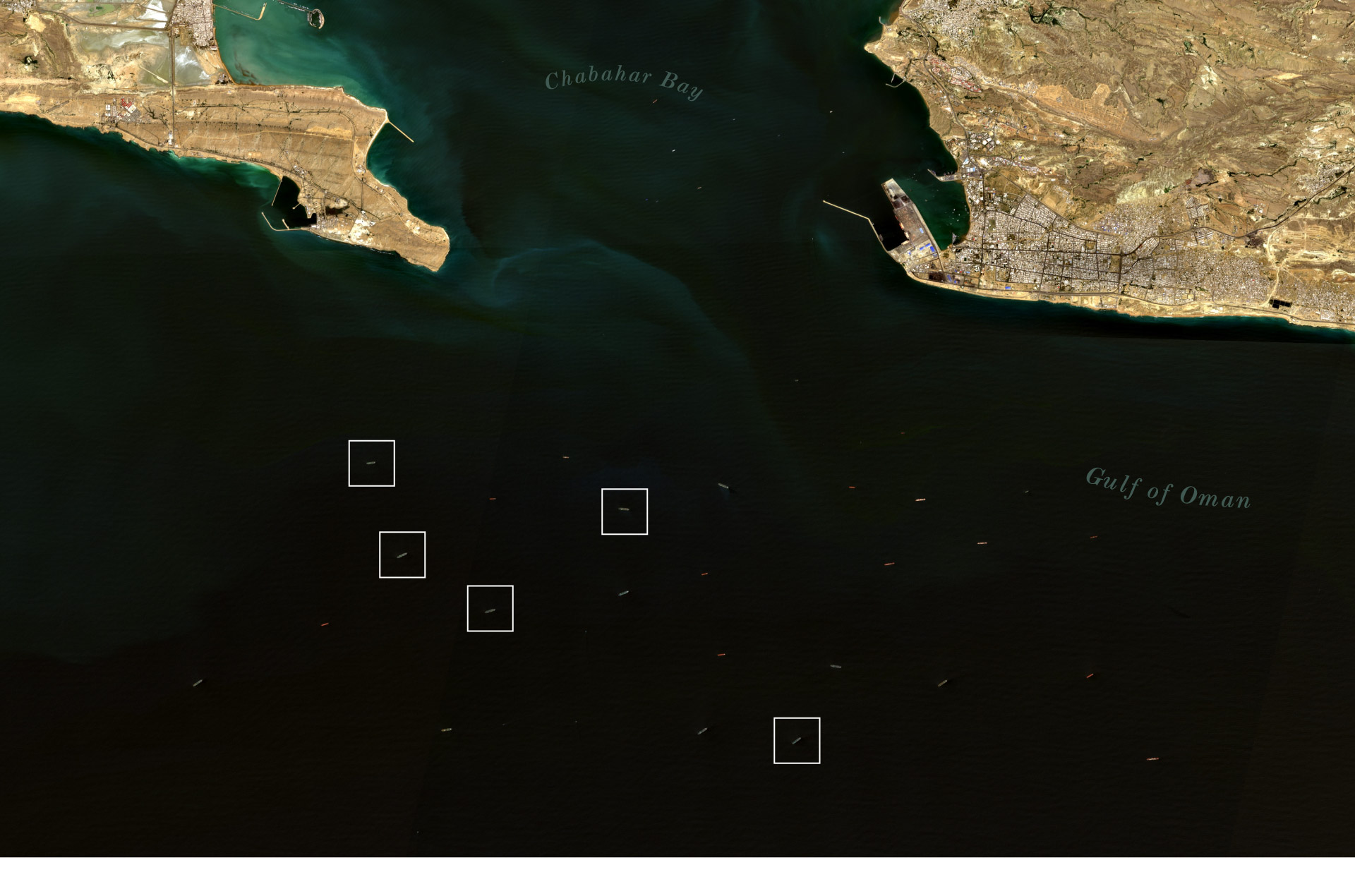
Chabahar Port
CHABAHAR
Sevin
Dorena
Snow
Dino I
Huge
Satellite image captured April 11, shows five Iranian tankers which have since departed the area. © Sentinel-2, European Space Agency 2026
Tankers Snow and Dino I had been anchored near Chabahar for around two weeks. Sevin and Dorena had been at the port since at least April 11, and Huge since at least April 6. They were laden with a collective 9 million barrels of Iranian oil before they left Chabahar Port, according to Tanker Trackers.
Where the tankers are now is not clear. Satellite imagery is incomplete, or in some case obscured by clouds, and the ships rarely publicly broadcast their locations.
The U.S. official declined to comment on their locations but said military officials “have a good understanding” of what is in the region and are prepared to pursue any vessels that attempt to thwart the blockade.
Editor’s note: Because ships can change their names, or can share names, The Post is including the International Maritime Organization numbers for each of the vessels mentioned in this story. They are: Hilda 1 (9357389), Silvia I (9172052), Amber (9357406), Arnica (9187643), Alicia (9281695), Rhn (9208215), Snow (9569619), Dino I (9569671), Sevin (9357353), Dorena (9569669), Huge (9357183), Yong Tai (9231511).
No comments:
Post a Comment